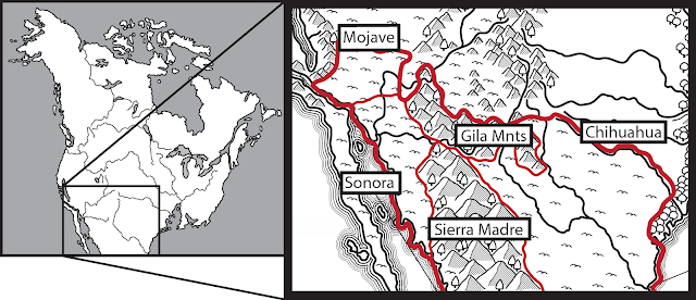
GNA - Southern Deserts & Temperate Sierras
The southern deserts consist of two broad areas divided into western and eastern halves by the Sierra Madre and Gila Mountains. In the east lies the Chihuahuan desert that transitions to the Great Plains to the north and the Atlantic further east. In the west the desert is divided between the low lying Sonoran in the south and the higher Mojave in the north. North of the Mojave lies the Great Basin, while the western limits of both deserts are marked by the Sierra Nevada. Further south of this desert heat and humidity grow so oppressive that human survival becomes untenable
The region has a subtropical desert climate that transitions to a semi-arid and steppe climate on mountainsides and a severe alpine climate at the highest peaks. The region tends to have hot summers and mild winters. In the deserts temperature averages around 30 C to around 13 C at the highest peaks. Rainfall is also highly seasonal, with a pronounced dry and wet season. In the western deserts, rain falls in powerful storms in winter but in the eastern deserts, this wet season occurs in the summer. In the central mountains, meanwhile, the rain season runs through summer-fall with a dry spring. Typically, rainfall is as little as 50mm in the low lying desert but increases to between 250-400mm in the mountains and is as high as 1000mm on the mountain peaks.
The southern deserts are marked by broad basins and isolated mountains. In mid elevations, ephemeral streams have formed alluvial fans and terraces. Mesas occur in the Chihuahuan desert and the terrain is generally sparser and more irregular. Meanwhile, in the Sonoran desert, long fault-block mountains occur and there are active volcanic fields. There is little surface water in an of the deserts beyond the rare spring or pond beds fed by groundwater. Streams are ephemeral or intermittent beyond a few proper rivers: the Colorado, Gala, and Grande. These rivers are much smaller than they were historically, as the glaciers that once fed them have long since disappeared. Finally, portions of all deserts are internally drained. In the Mojave especially this has resulted in the formation of playa and dry lake beds.
The mountains are largely volcanic and marked by steep slopes, dissected plateaus, and deep canyons. Elevations range from 1300m to 3300m. Springs occurs throughout, feeding the growth of oases by eroding bedrock. There are also small ponds and reservoirs that feed ephemeral streams which flow into the larger rivers that cut through the lowlands. Throughout the Sierra Madre are a number of southwest-northeast running corridors which allow the migration of lowland animals through the mountains.
The southern deserts are dominated by cacti, scrublands, and grasslands. There are also barren areas where sand dunes occurs. In the Mojave, cacti are rarer and scrublands are dominated by creosote bush and various yucca. It also features salt flats that support saltbush and saltgrass. On scattered mountains - called 'sky islands' - trees occur throughout the Mojave and Chihuahuan desert, though in the Sonora, the highlands support trees only along springs and seeps. The Mojave mountains feature a mix of juniper, pinyon, pine and fir. In the Chihuahua meanwhile, mountains support juniper, pinyon, and oak. In the south of the Sonoran desert, especially along the banks and mouth of the Colorado, there are extensive forests of tamarisk, occasionally intermixed with cottonwood and willow.
In the mountains, woodlands of pinyon, juniper, and oak are common at middle elevations, transitioning to dense forests of pine, fir and aspen. In lowlands, shrublands and grasslands occur, exacerbated by ancient forestry and overgrazing. Tropical forests occur in sheltered canyons along waterways.
The southern deserts are largely devoid of human life, less than 1 person per square mile. Small numbers of goat and camel herds practice vertical pastoralism spending the hottest parts of the year in the cooler foothills and travelling the basins only rarely. In the wetter and cooler mountains sedentary agriculture occurs where oases, ponds, and streams provide water or along the few rivers there. This agriculture relies on extensive irrigation. Humans also occur more densely along the gulf of California, especially in the marshy delta of the Colorado and Gila rivers. Here fisherfolk, similar to those of Beja California, can be found living in villages along the sea.


Comments
Post a Comment