Posts

GNA - Northern Forests

Image
The northern forests consist of all wooded parts of Canada east of the Rocky Mountains to the Arctic Ocean to the north and Atlantic ocean to the east. Its southern limits are marked by a transition to the subtropical forests of the south-east at the Great Lakes. The forest, except for a flat and swamp strip along the coast of the Hudson Bay known as the 'Hudson Lowlands', is dominated by coniferous forest which grows thick on wrinkled landforms cut through by rivers and dotted with lakes or muskeg swamplands. In the south, where trees grow to full height, the region is considered 'boreal', while in the north where cold weather and irregular sunlight causes trees to grow stunted or gnarled, and the region is called 'taiga'. Further, the region can be divided into the silty-bottomed Mackenzie River valley in the west and the Canadian Shield - a vast rounded outcrop of bare bedrock which covers the territory of Nunavut, as well as much of the provinces of Manitoba

GNA - Southern Deserts & Temperate Sierras

Image
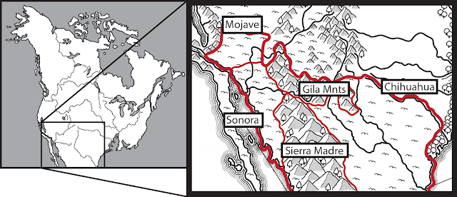
  Map of the Southern Deserts - by Me! The southern deserts consist of two broad areas divided into western and eastern halves by the Sierra Madre and Gila Mountains. In the east lies the Chihuahuan desert that transitions to the Great Plains to the north and the Atlantic further east. In the west the desert is divided between the low lying Sonoran in the south and the higher Mojave in the north. North of the Mojave lies the Great Basin, while the western limits of both deserts are marked by the Sierra Nevada. Further south of this desert heat and humidity grow so oppressive that human survival becomes untenable Great Canyon on the Gila River - Seth Eastman The region has a subtropical desert climate that transitions to a semi-arid and steppe climate on mountainsides and a severe alpine climate at the highest peaks. The region tends to have hot summers and mild winters. In the deserts temperature averages around 30 C to around 13 C at the highest peaks. Rainfall is also highly seasonal

HotT beholder

Image
 I had an idea for how to use some plastic ant antenna I had collected while converting the Tyranid ships for G&G Battlefleet Gothic - 6mm beholders! First, i looked through a collection of beads my mother kindly offered to me and found two that measured a little under 1cm across. I glue these to paper-clip flight stands and filled the hole on top with superglue. Next, I took 20 of the ant antenna and glue 10 to the top of each bead to form the beholder's eye tentacles. An image of the finished figures before painting Next came painting! It took four coats to get an even colour on the miniatures due to the slipperiness of the beads. Doing a pre-coat with watered down white glue may have help the paint stick more quickly and evenly but ultimately the result was more than satisfactory. For the eyes, I started by painting the rough shape in black, adding thick black dots to the end of each tentacle. Next came white, followed by an iris of orange for the red beholder and yellow for

HotT Dragons Part 1

Image
 A big dream of mine is making miniature representations of the creatures in the AD&D monster manual. I've never had a lot of funds for miniatures which has instilled in me an interest in gaming on a budget. The holy grail of  D&D and cheap miniatures are the chinasaurus - plastic dinosaur toys which gave rise to creative monsters like the bulette, owlbear, and rust monster. Examples of figures I started with.  With this inspiration in mind, a bought a pack of cheap plastic dragons from the dollar store to use to make the different D&D chromatic dragons to use in various games. I started by going through the pack, choosing dragons that best matched the description and artwork in the monster manual. In addition to have one of each of the classical chromatic dragons, I managed to make two wyverns (allowing for one with a rider) buy trimming the front legs off of two of the smallest dragons in the pack. I also removed the wings from two of the beasties to use as a brown dr

Battle Fleet Gothic - DIY Tyranid Ships

Image
 After a series of setbacks and stalls on my Ork Roks, I haven't been feeling excited about Battle Fleet Gothic as much. That said, I managed to acquire some cheap plastic creepy crawlies that I wanted to try to convert into Tyranid bug ships which I hoped would be easier to assemble and paint. The crawlies in question I started with one single large plastic crab (destined to become my hive ship) and a few ants. I wanted to create at least three different kinds of vessels to give my forces some variety and also wanted to try basing a squadron of smaller vessels. So, the plan was to create one large flagship, a medium-sized 'cruiser', and a smaller collection of 'destroyer' or 'frigate' sized vessels.  I began (completely without a plan) by taking the plastic ants and chopping off the head and all the limbs. I noticed the heads, once they had the antenna removed, looked similar to horseshoe crabs - a great base for my 'destroyers'. I experimented brie

GNA - The Two Californias

Image
Map of the Californias - by Me The Californias include mainland California and the island of Baja California. The mainland is composed for the temperature lands surrounding the Sacramento bay and the mountains which ring it - the Klamath mountains to the northwest, Sierra Madre to the east, and the San Gabriel and San Bernardino mountains to the south. These southern mountains as split in half by the San Andreas Straight, with one half of both ranges remaining on the mainland and the other forming the northernmost portion of the island of Baja California, beyond which is desert. Monterey Coast - Guy Rose The climate of mainland California is semi-arid Mediterranean with mild, wet winters and dry, hot summers. The average temperature in summer is 30 C while in winter it is about 20 C. Temperatures tend toward mild on the pacific coast and along the Sacramento Bay. Meanwhile, at high elevations like the southern mountains, summer temperatures become more varied and cooler in general, as

GNA - Arctic Archipelago

Image
Map of the Arctic Islands - by Me The harshest environment of North America, this region includes all of the non-tree baring islands of the Arctic ocean. Once covered in permafrost, which helped to trap moisture in the ground, the warmer southern months have allowed this water to escape turning it into a frigid desert. Its flora, where it occurs, consists mostly of herbs, lichen, and dwarf shrubs Pangnirtung Fjord, Auyuittuq National Park, Baffin Island - Ruth Driedger The Arctic archipelago has a frigid semi-arid climate with short, cool summers and long, cold winters. Average daily temperatures in the summer are 10 C while in winter they average less than -30 C. Annual precipitation ranged from about 300mm to 500mm. Highlands, mostly bare rock, are unable to hold water and so it tends to pool in low-lying lakes, rivers, and muskegs. Most characteristic of the climate of the far north is the immense seasonal fluctuation in the length of daylight. In the warmest months the sun can stay